
Posted by: Geology Tiger August 17, 2012
Login in to Rate this Post:
0  ?
? 
?
Image and summary credit: NASA/JPL-Caltech/MSSS
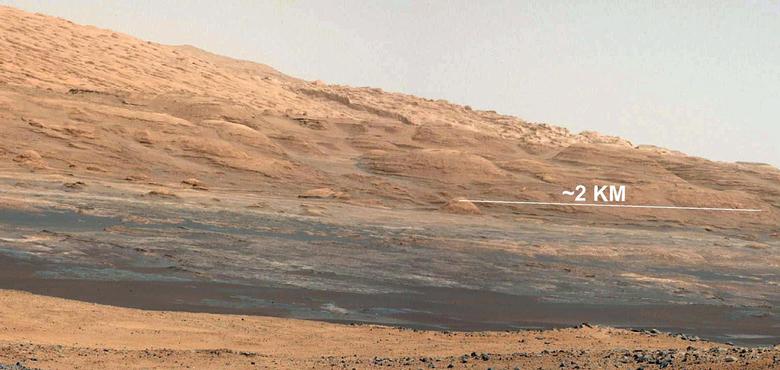
The Promised Land
This image (cut out from a mosaic) shows the view from the landing site of NASA's Curiosity rover toward the lower reaches of Mount Sharp, where Curiosity is likely to begin its ascent through hundreds of feet (meters) of layered deposits. The lower several hundred feet (meters) show evidence of bearing hydrated minerals, based on orbiter observations. The terrain Curiosity will explore is marked by hills, buttes, mesas and canyons on the scale of one-to-three story buildings, very much like the Four Corners region of the western United States.
A scale bar indicates a distance of 1.2 miles (2 kilometers).
Curiosity's 34-millimeter Mast Camera acquired this high-resolution image on Aug. 8, 2012 PDT (Aug. 9 EDT).
This image shows the colors modified as if the scene were transported to Earth and illuminated by terrestrial sunlight. This processing, called "white balancing," is useful to scientists for recognizing and distinguishing rocks by color in more familiar lighting.
http://www.nasa.gov/mission_pages/msl/multimedia/pia16073.html
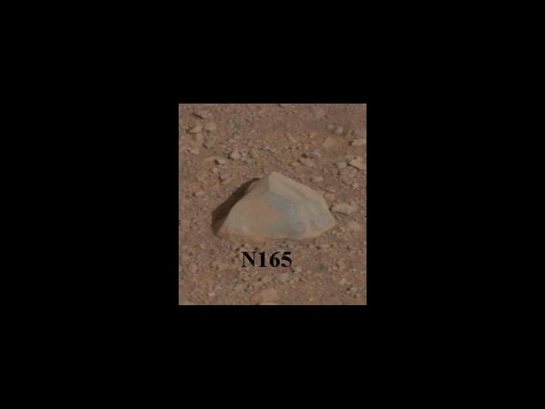
Curiosity's First Rock Star, Up-Close
This close-up image shows the first target NASA's Curiosity rover aims to zap with its Chemistry and Camera (ChemCam) instrument. ChemCam will be firing a laser at this rock, provisionally named N165, and analyzing the glowing, ionized gas, called plasma, that the laser excites. The instrument will analyze that spark with a telescope and identify the chemical elements in the target.
The Promised Land
This image (cut out from a mosaic) shows the view from the landing site of NASA's Curiosity rover toward the lower reaches of Mount Sharp, where Curiosity is likely to begin its ascent through hundreds of feet (meters) of layered deposits. The lower several hundred feet (meters) show evidence of bearing hydrated minerals, based on orbiter observations. The terrain Curiosity will explore is marked by hills, buttes, mesas and canyons on the scale of one-to-three story buildings, very much like the Four Corners region of the western United States.
A scale bar indicates a distance of 1.2 miles (2 kilometers).
Curiosity's 34-millimeter Mast Camera acquired this high-resolution image on Aug. 8, 2012 PDT (Aug. 9 EDT).
This image shows the colors modified as if the scene were transported to Earth and illuminated by terrestrial sunlight. This processing, called "white balancing," is useful to scientists for recognizing and distinguishing rocks by color in more familiar lighting.
http://www.nasa.gov/mission_pages/msl/multimedia/pia16073.html
Curiosity's First Rock Star, Up-Close
This close-up image shows the first target NASA's Curiosity rover aims to zap with its Chemistry and Camera (ChemCam) instrument. ChemCam will be firing a laser at this rock, provisionally named N165, and analyzing the glowing, ionized gas, called plasma, that the laser excites. The instrument will analyze that spark with a telescope and identify the chemical elements in the target.